About AIS Maps: Marine & Lake charts
Discover a new perspective on the world with AIS Maps: Marine and Lakes Charts by FlyToMap. Our app is meticulously crafted, offering a seamless blend of aesthetic appeal and functionality. Witness the world in intricate...
Discover a new perspective on the world with AIS Maps: Marine and Lakes Charts by FlyToMap. Our app is meticulously crafted, offering a seamless blend of aesthetic appeal and functionality. Witness the world in intricate detail, thanks to vector-based map elements that maintain their crispness even when zoomed in, and experience smooth panning, tilting, and rotating for a consistently immersive view.
Unlock the full potential of FlyToMap with our in-app purchase business model, providing access to a comprehensive array of maps, including Marine, Travel, Parks, and Lakes. All these maps are available for offline use at reasonable costs.
Key Features:
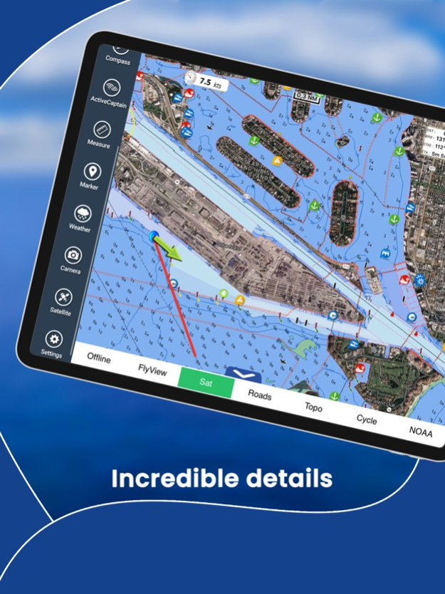
Live AIS Experience real-time map views of your boat and nearby vessels worldwide without the need for an AIS receiver—just your mobile device. Various icons denote different vessel categories, and selecting a target reveals detailed information such as name, MMSI, IMO, call sign, status, speed, heading, coordinates, distance from your GPS location, and more.
Free Features and Functions:
• Latitudes and Longitudes for easy navigation
• Direct search for your favorite points
• Intuitive zoom, rotate, and pan with a touch
• Quick object information with vector technology
• GPS heading for precise navigation
• Distance measurement tool for easy calculations
• Route planning with real-time speed, distance, and bearing updates
• Magnifying lens for detailed information
• Unlimited tracks, markers, geo-tagged photos, and records
• Shareable via email and visible on Google, Flytomap Viewer, and KMZ format
• Depth contours selection
• Background functionality for multitasking
• Optimized battery usage
• Local marine weather forecasts at your fingertips
Marine Maps: Explore detailed Electronic Nautical Charts (ENC) with information on coastline, anchoring areas, fishing spots, restricted areas, obstructions, rocks, buoys, beacons, lights, depth contours, spot soundings, and more.
Lake Maps: Access high-quality lake maps featuring depth contours, boat ramps, fishing spots, trails, roads, and railways information.
Park Maps: Discover advanced electronic charts with hiking, biking, and equestrian trails, as well as points of interest like campgrounds, visitor centers, lookout points, eateries, ranger stations, picnic areas, boat/canoe ramps, and parking areas.
Travel Maps: Explore the most captivating tourist areas, combining sea and land information for a comprehensive travel experience.
Stay connected with us:
• Twitter: @flytomap
• Web: flytomap.com
• Facebook: facebook.com/flytomap
Embark on a journey of exploration and navigation like never before with AIS Maps: Marine and Lakes Charts by FlyToMap.
Feb 8, 2024
Version 6.4.0
Charts added:
Georgian Bay South
Hudsonriver to Raritanbay
Lake Ontario West
Lake Huron South
Lake Erie East
Lake Huron North
Thousand Islands
Lake Ontario East
Prince William Sound
South Cook Inlet
Shelikof Strait
East Kodiak Island
East Andreanof Islands
Previous Versions
Here you can find the changelog of AIS Maps: Marine & Lake charts since it was posted on our website on 2021-12-14 05:46:59.
The latest version is 6.4.0 and it was updated on 2024-04-19 19:52:29. See below the changes in each version.
AIS Maps: Marine & Lake charts version 6.4.0
Updated At: 2024-02-08
Changes: Feb 8, 2024
Version 6.4.0
Charts added:
Georgian Bay South
Hudsonriver to Raritanbay
Lake Ontario West
Lake Huron South
Lake Erie East
Lake Huron North
Thousand Islands
Lake Ontario East
Prince William Sound
South Cook Inlet
Shelikof Strait
East Kodiak Island
East Andreanof Islands
AIS Maps: Marine & Lake charts version 6.3.19
Updated At: 2023-12-20
Changes: Dec 20, 2023
Version 6.3.19
Charts added:
Behm Canal
Bristol Bay
Cape Ulika
Cross Sound - Icy Strait
Delarof Islands
Dixon Entrance
East Andreanof Islands
Northern Cook Inlet
Norton Sound
Peril Strait
Rat Islands
Shumagin Island Sound
Taku Harbor Skagway
Tortuga to Margarita Island
West Kodiak Island
Whal Bay - Peril Strait
Wrangell - Glass Penisula
AIS Maps: Marine & Lake charts version 6.3.18
Updated At: 2023-02-24
Changes: Feb 24, 2023
Version 6.3.18
Charts added:
Lake Superior East
Maui-Oahu
Hawaii-Maui
Johnston Atoll
Lake Michigan North
North Channel
Lake Michigan South
Georgian Bay Northeast
Main Channel
Lake Erie West
AIS Maps: Marine & Lake charts version 6.3.11
Updated At: 2022-08-06
Changes: Aug 6, 2022 Version 6.3.11
Charts added:
Strait of Georgia
Desolation Sound
Port Neville Blunden Harbor
Queen Charlotte Strait
Northwest Vancouver Island
Nootka Sound Chart
Clayoquot Barkley Sound
Kings Island
Namu Harbor Hiekish Narrows
Caamano Sound Laredo Sound
AIS Maps: Marine & Lake charts version 6.3.8
Updated At: 2022-02-04
Changes: Feb 4, 2022 Version 6.3.8
Charts added:
Woods Reservoir Tennessee
Reelfoot Lake
Lake Ray Roberts
Tims Ford Lake
North-South Lake
Lake Tiorati
Tunisia
Oslo
Puerto Rico
Vancouver Approaches
AIS Maps: Marine & Lake charts version 6.3.7
Updated At: 2022-01-26
Changes: Jan 26, 2022 Version 6.3.7
Charts added:
Logan Martin Lake
Table Rock Lake
Lake Wakatipu
Norfork Lake
Mill Wood Lake
Madeira Islands
Virgin Islands
Lake Whitney
Waurika Lake
Sauk Lake
Mississippi River Pool 10
Hodstradt Lake
Zurichsee
AIS Maps: Marine & Lake charts version 6.3.6
Updated At: 2021-12-15
Changes: Dec 15, 2021 Version 6.3.6
Update of American Charts
AIS Maps: Marine & Lake charts version 6.3.5
Updated At: 2021-11-10
Changes: Nov 10, 2021 Version 6.3.5
Charts added:
Saginaw Bay
Lake Shelbyville
Vanern
Vattern
Malaren
Lake Taupo New Zealand
Stora Le
Lake Norris Tennessee
Lake Wallenpaupack
Disclaimer
Official App Store Link
We do not host AIS Maps: Marine & Lake charts on our servers. We did not scan it for viruses, adware, spyware or other type of malware. This app is hosted by Apple and passed their terms and conditions to be listed there. We recommend caution when installing it.
The App Store link for AIS Maps: Marine & Lake charts is provided to you by apps112.com without any warranties, representations or guarantees of any kind, so access it at your own risk.
If you have questions regarding this particular app contact the publisher directly. For questions about the functionalities of apps112.com contact us.